Abstract
I will show here how distances between line of longitude increase much faster in the Un Azimuthal Flat Earth model than they do in the Spherical model. The distance data provided by Google is determined to derived by the same models presented here so cannot be used to distinguish which model is correct. However with Flat Earth providing results rapidly diverging from spherical this method provides a simple way to test which geometry the planet has. At the end of the post I expand the model to find distances in all direction. I know people living in Sydney who say the distance to Canberra takes around 2 hours to drive. 2 hours at 70mph is 224km. This is almost exactly the result expected by the round Earth model proposed and half that predicted by the Flat Earth model. There are a huge number of Flat Earth models, indeed any manifold geometry is a candidate, nevertheless none of them have the property that distances in all directions relate to reality. There is no known flat map where the distance from Sydney to Canberra looks the same as the distance from London to Sheffield. This is the problem to solve for Flat Earth theory. I then examine the philosophy of Flat Earth and provide a spiritual interpretation of its desire for boundlessness with brief guidance how to enter the infinite.
A bit of theory
To be clear about words first. A line of Longitude is a N/S line, or a spoke in the wheel radiating out from the North Pole. A line of Latitude is an E/W line, or a rim of the wheel or clock, going around the North Pole. A line of Longitude joins points of the same Longitude, and a line of Latitude joins points of the same Latitude. Perhaps confusingly then the Latitude of a point is its position along a spoke of Longitude, and the Longitude is the position around the clock of Latitude. There is actually a deep relationship between the ideas of clock faces and latitude.
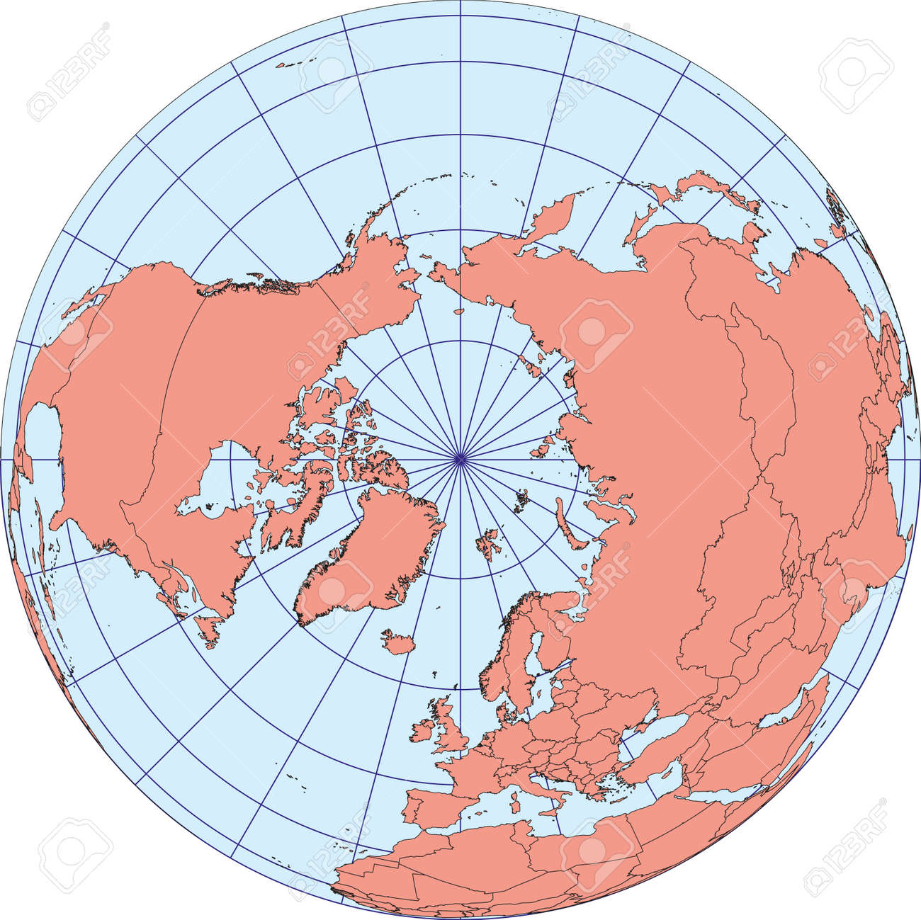
Here is one version of the flat earth map from Flat Earth Society.

The key thing to note is that the lines of latitude expand evenly from the North Pole. Compare this with looking down on a Sphere where they bunch up as you approach the equator.
Using the first model (there are others) we divide the diameter of the Flat Earth Disk up evenly. If the disk has a diameter D, then the diameter of a circle of latitude (φ) with φ ranging evenly, North Pole to Disk Edge, π/2 >= φ >= -π/2 is:
dl = D (π/2 - φ )/π [1.0]
This gives the distance around a line of latitude:
π dl = D (π/2 - φ) [1.1]
The distance of a point from the North Pole (rl) in both models in terms of latitude is half the diameter in 1.0:
rl = dl/2 = D/2 (π/2 - φ)/π = r (π/2 - φ) [1.2]
Where D/2π = r [1.3]
In the spherical model r is interpreted at the radius of the sphere. In the disk r is a mysterious constant.
2 π r Cos(φ) [2.0]

Cardiff and London are E-W of each other and selected here on Mapfrappe. They have latitude (φ) = 51.5 degrees (0.90 radians)
If we move to latitude (φ) 5.6 degrees (0.10 radian), the longitude of London runs through Accra in Ghana, and the longitude of Cardiff runs through Ayame.
On the maps these lines of Longitude, the spokes, are straight and radiate out from the North Pole as seen in the flat earth map. The Flat Earth map is actually best to visualise this, but the same logic applies to the sphere model too. It doesn't matter how long the spokes are, the distance along the wheel rim between two spokes is always the same proportion of the whole wheel (the line of latitude). This means that if we know the distance between spokes along the rim of one wheel size we can work out the distance between the same spokes on a wheel of any size by scaling or stretching the wheel. Latitude (φ) is the measure of wheel size in these models. So if we know the distance between two points on the rim (same latitude) then using φ we can scale the wheel to any latitude and find the distance between points on those spokes (longitude). What is interesting is that the stretch is different depending upon what model you use for the shape of Earth. So by looking at which stretch works best we can determines the best model for the Earth shape.
On Flat Earth the stretch is (from 1.1):
D (π/2 - φ2) / [D (π/2 - φ1)] = (π/2 - φ2) / (π/2 - φ1) [3.0]
While on the Sphere the stretch is (from 2.0):
2 π R Cos(φ2) / [2 π R Cos(φ1)] = Cos(φ2) / Cos(φ1) [4.0]
So on Flat Earth this stretch from London/Cardiff to Accra/Ayame is (from 3.0):
(π/2 - 0.1) / (π/2 - 0.9) = 2.2
So we'd expect the distance between Accra and Ayame to be 2.2x the distance between London and Cardiff on the flat disk.
However on the sphere the stretch from the other equation is (from 4.0):
Cos(0.1) / Cos(0.9) = 1.6
On a sphere we'd expect the distance between Accra and Ayame to be 1.6 times the distance between London and Cardiff.
So which is it? The general model at the end uncovers the fact that Google Maps simply uses the same spherical equations presented here to estimate distances. But if Google Maps was giving false distance data we would expect it to have been noted by now. It is interesting that to my knowledge people aren't finding their car milometers to be hugely different from their google map journeys.
I also note that Flat Earth is giving a distance between Accra to Ayame to be 37.5% larger than Spherical Earth. This is a huge distance. Even if someone in the area drives the journey with only 25% accuracy it would give us enough precision to test which model is more accurate.
In the general model below it is shown that the divergence grows so that Sydney to Adelaide is twice as far in the Disk model as Globe model with the Globe model fitting the data perfectly.
Summary
The idea of comparing distances between lines of longitude down the latitudes can be used anywhere on Earth and if you have colleagues in places far away North or South of you then you can test this directly. Ideally a long straight road between lines of longitude that you can drive to actually measure the distance would be perfect. You can also uncouple lines of longitude and compare distances at different latitudes since a degree of distance at any latitude is the same around the line of latitude. This way we can test this even with people not North or South of you.
Obviously for places close you need to measure very accurately. In UK lines of longitude passing through North Scotland and Devon provide only 3.5% difference between Flat Earth and Sphere models so to test in UK measurement would need to be very accurate.
Conclusion
It would appear that this method reveals a big difference between flat earth and spherical models which can be used to test which is more accurate. I note that the existing online Google Maps resource uses the same distance model presented at the end of the article. To my knowledge this hasn't been challenged over its accuracy as is used every day my millions. However no solid data has been found at this stage to determine once and for all which model is more suitable for modelling the Earth's geometry.
After Thought
So what is the reason for Flat Earth model anyway? Originally it was the most obvious description of the world. When we walk a distance we feel it is flat. Curvature only becomes relevant when we cover great distances and for most people this didn't happen until the 20th Century. I have met someone in Cumbria whose mother was the first woman ever in her family to leave the valley in which the family lived. Curvature was not an issue for this family.Today Flat Earth has a new meaning. It represents the idea of unlimited borders. The problem with the globe model is that space is limited and horizons all point home. In Flat Earth looking out means we look to the infinite. A huge irony is that Flat Earth tends to reject the infinite cosmos model and thinks that looking up is into a finite dome. But ultimately the sensibility is to reject what we have been told and to experience the wonder of the unknown and infinite. In a world where we are overwhelmed by information, authorities, experts and the known such a simple system of rejection once again gives us control and meaning in the world.
It is however a dangerous move to gain freedom so crudely. Others can simply just reject the authority of the flat earth and so it goes on endlessly.
True freedom is quite different. What people don't realise is that they are already entirely free and that our mind is always infinite and unbounded already. There is simply nothing to do, nothing to believe, no faction to side with and no one to join. We are already entirely free.
Such freedom is bewildering to those brought up on a diet of knowledge and fixed beliefs. Flat Earth is ironically exactly the type of prison that those adopting flat earth think they are escaping. NASA is the governmental authority fooling the people, we reject such thought control and seek freedom in the dogma of the flat earth. Of course really this becomes just another dogma. Why pin your existence on any silly thought or model? This is not football and no one cares which team wins.
To annihilate the overload of information, to escape the talking heads and authorities which try to enforce themselves upon our world, to enter the infinite and unbounded existence of True Mind we must first learn to abide in the infinite space of the Present Moment, undistracted and unburdened by worries of Truth or Authority or Freedom. We need only focus on what nourishes our soul and what is sees as Good, with no worries of politics, persuasion or correctness at all.
See this random video. Let go of thoughts of what the Sun is, what shape the sky, why the waves ripple, what is creating those sounds these are all only thoughts. Instead observe only what is in the senses: what does the bright orb look like, there is a shimmering line before it, each ripple is different from any ripple ever produced in this universe, look at each one and see its uniqueness, watch them move toward the shore and how each one arrives differently, there are no ripples in the sky: examine what is in the eyes. There are sounds! What are they like? Soft sounds, long sounds, pulsing sounds or smooth sounds, simply examine what is in the ears. When more practiced examine and see what is in the feelings and even what is in the thoughts (which obviously right now is thoughts about what is being written). In the video thoughts may be "near thoughts" like "what is making that sound?" and we think "bird": watch that thought happen. We didn't have that thought a minute ago, now we do, sometime soon we won't have it again. It has happened, it is just a thought - it isn't a bird! That sound is not actually a bird, it is a sound, birds don't exist in our ears, we think "bird" separately in our thoughts (this is very advanced contemplation, will take time). Or there are "far thoughts" like I don't have time to do this or I have money worries, watch those thought happen and come back to the senses. There may be "far feelings" like anxieties or worries: observe these exactly the same, they come and go. Worries have a habit of attracting thoughts, stirring up a thousand reasons and thoughts why we need take action and get rid of the worries. Just for now, free yourself and ignore them, with the promise to attend to them tomorrow or later, if necessary be reckless with all worries, be Jesus dying on the Cross, that's as bad as it gets, how bad really are our feelings or concerns? Eventually simply let thoughts and feelings drift away from centre stage and allow time happening in our senses to be there instead. We are only limited and bounded by these thoughts and feelings; they are only our tool for encountering the world, like flat/round earth they are mental models but are not our master. Let them all go now. Enter instead gradually and imperceptibly into the sense world that surrounds and fills you. Then you have taken the first step to gaining mastery of your mind and seeing infinite freedom.
The General Model
The maths above is made easy by considering only distances along lines of latitude. You can however develop the model for distances in any direction.
Given two co-ordinates: (φ1, λ1) and (φ2, λ2) the distance between them on the Disk can be calculated using 1.2 to convert the coordinates to radii with the absolute difference in longitude (Δλ) and the Cosine Rule thus:
 [5.0]
[5.0] [6.0]
[6.0]
the distance (d) between the points on a sphere with radius r is then given by:
 [6.1]
[6.1]
(Wiki notes that this is formula is not accurate for points close together and better, but more complex, functions are available.)
Using Mathematica equation 5.0 reduces to equation 3.0 for two pairs of points with same radius each and sharing Δλ. Curiously 7.1 only approximates to 4.0 under the same conditions. (Why is this?)
We know that there is a big divergence between the models approaching the equator from above. The distance from Ayame, Cote d'Ivoire (5.604497° N, 3.156939° W) to Accra (5.6037° N, 0.1870° W) using these equations is:
Using 5.0 for disk model: 486.39km
Using 6.1 for sphere model: 328.67km
Google Maps gives a distance of 328.67 km. So we have established that Google Maps is using the same equation presented here.
What we have established is that the disk model gives a result 48% more than the sphere model. This is easy to test. It appears we just need data from countries far from the North Pole to distinguish which model is best.
The divergence grows going into the Southern Hemisphere.
The distance between Sydney and Canberra is given by Google as 228.564km.
Obviously the Sphere model presented here agrees. But the Disk model gives a distance of: 468.023km.
Google Directions give the driving distance as 259km. It is easy to test whether cars can drive between Canberra and Sydney in under 400km and distinguish which model is better.


No comments:
Post a Comment